top of page

Map & Model
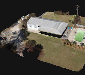
RGB 3D Model
This 3D model captures the full property in crisp, true-color detail, offering an interactive way to examine rooflines, landscaping, and overall structure from every angle.
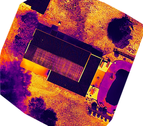
Thermal Orthomosaic Map
This georeferenced thermal map delivers a precise, top-down view of the entire property’s heat signature—an essential tool for assessing irrigation, energy efficiency, or hidden damage.
Thermal 3D Model
The thermal 3D model reveals temperature differences across the home and surrounding surfaces, ideal for identifying heat loss, insulation issues, or active systems.

Digital Surface Model (DSM)
The DSM highlights terrain and elevation changes, helping to understand drainage patterns, ground slope, and construction suitability with precision.

bottom of page